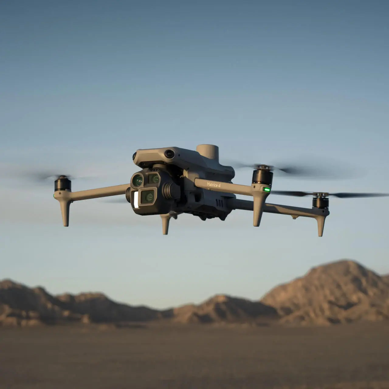
DJI Matrice 4E Enterprise Drone
New & Un-Activated Unit
This Item Ships FREE
Description
DJI Matrice 4E: High-Precision Mapping and Surveying Platform
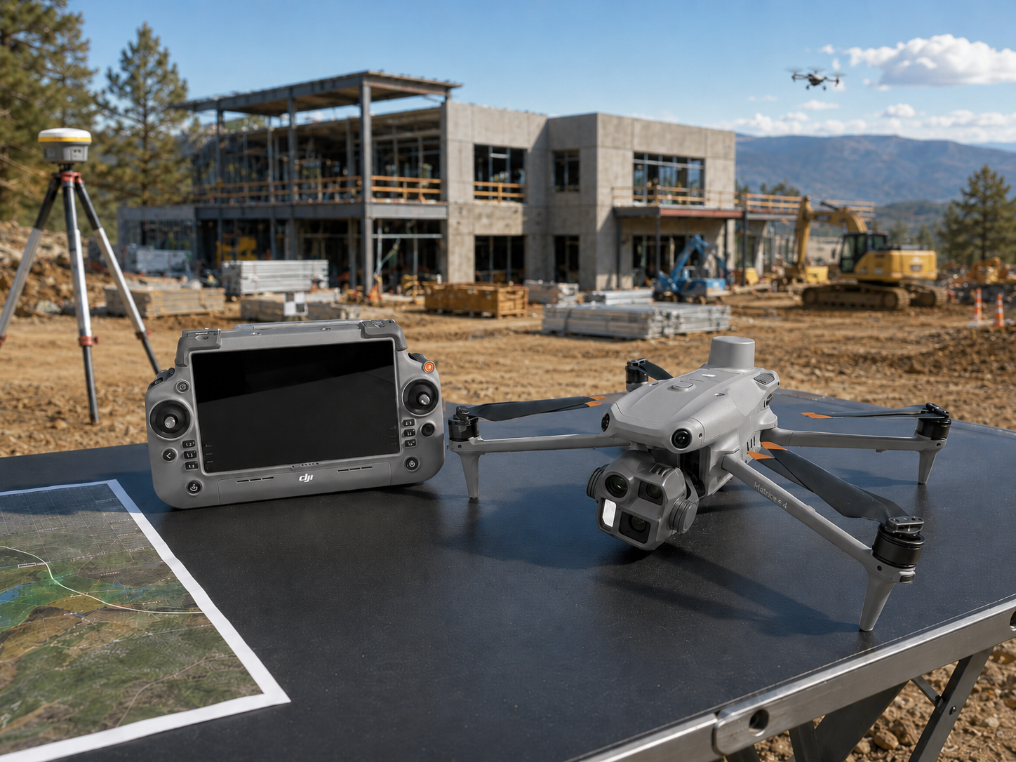
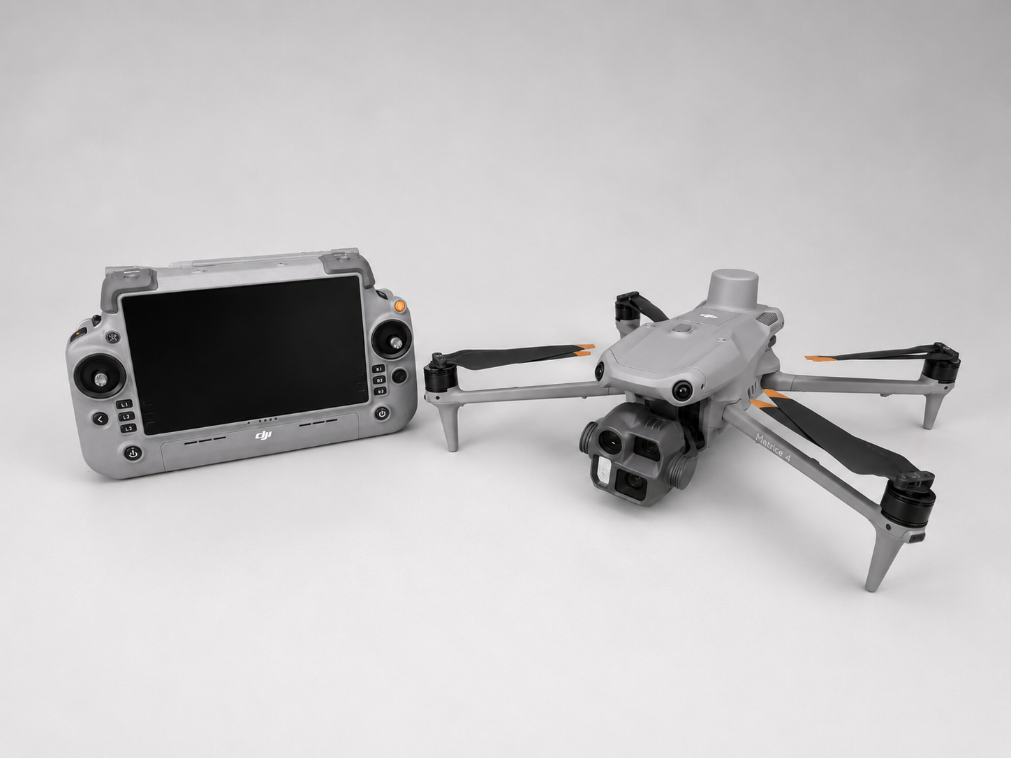
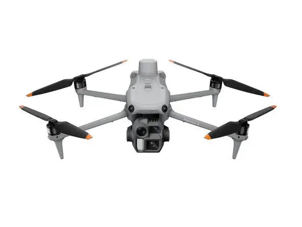
The DJI Matrice 4E is a next-generation enterprise drone designed specifically for high-accuracy mapping, surveying, construction monitoring, and industrial inspection workflows. Built for professionals who require precise geospatial data and efficient aerial workflows, the Matrice 4E delivers powerful imaging performance, intelligent automation, and reliable flight stability in demanding environments.
Compact and easy to deploy, the Matrice 4E is engineered to streamline data collection while maintaining the accuracy and consistency required for professional surveying and GIS applications.

Key Features and Benefits
Unparalleled Mapping Efficiency
- Extended Flight Time: Boasting a maximum flight time of 49 minutes, the Matrice 4E enables longer, more productive missions, minimizing downtime and maximizing operational output.
- 5-Directional Oblique Capture: This advanced feature improves mapping efficiency by up to 40%, enabling detailed 3D reconstructions and comprehensive aerial surveys.
- High-Speed Data Collection: With a 0.5-second capture interval, the Matrice 4E can collect data faster than ever, reducing operational time and increasing project throughput.
Precision Redefined
- Distortion Correction 2.0: Advanced distortion correction technology ensures residual distortion of less than two pixels, providing unmatched accuracy for aerial mapping and modeling.
- Factory-Calibrated Cameras: Each wide-angle camera is calibrated before leaving the factory, ensuring high-precision outputs. Combined with DJI Terra (available separately), the system delivers superior reconstruction accuracy.
Simplicity and Safety in Every Operation
- Smart 3D Capture: This innovative feature allows users to generate precise mapping routes and detailed 3D models directly from the RC Plus 2 remote controller, eliminating the need for additional devices.
- Enhanced Obstacle Avoidance: Navigate complex environments with confidence, thanks to robust obstacle avoidance systems that prioritize operational safety.

Applications
Surveying and Mapping
- Large-Scale Aerial Surveys: The Matrice 4E’s extended flight time, multi-directional capture, and high-speed data collection make it ideal for government departments, surveying firms, and planning organizations.
- Topographic Data Collection: Achieve unparalleled accuracy in digital terrain modeling and mapping with distortion correction and DJI Terra integration.
Construction and Planning
- Site Development and Modeling: Generate precise, detailed 3D models of construction sites and infrastructure projects, ensuring accurate planning and execution.
- Building Modeling: Perfect for architectural heritage conservation, detailed modeling projects, and fire safety planning.
Asset Inspections
- Infrastructure Inspections: Conduct thorough evaluations of bridges, buildings, and other structures using high-resolution imaging and flexible zoom options.
- High-Resolution Surface Analysis: Capture intricate details of surfaces for maintenance, repair, and operational assessments.
Why Buy the DJI Matrice 4E from Altitude Drones?
When you purchase your DJI Matrice 4E from Altitude Drones, you’re working with an authorized DJI dealer trusted by professionals nationwide since 2011.
We provide expert guidance, competitive pricing, fast shipping, financing options, and ongoing support to ensure your drone program operates at peak efficiency. From initial setup to long-term fleet expansion, Altitude Drones is here to support your mission every step of the way.
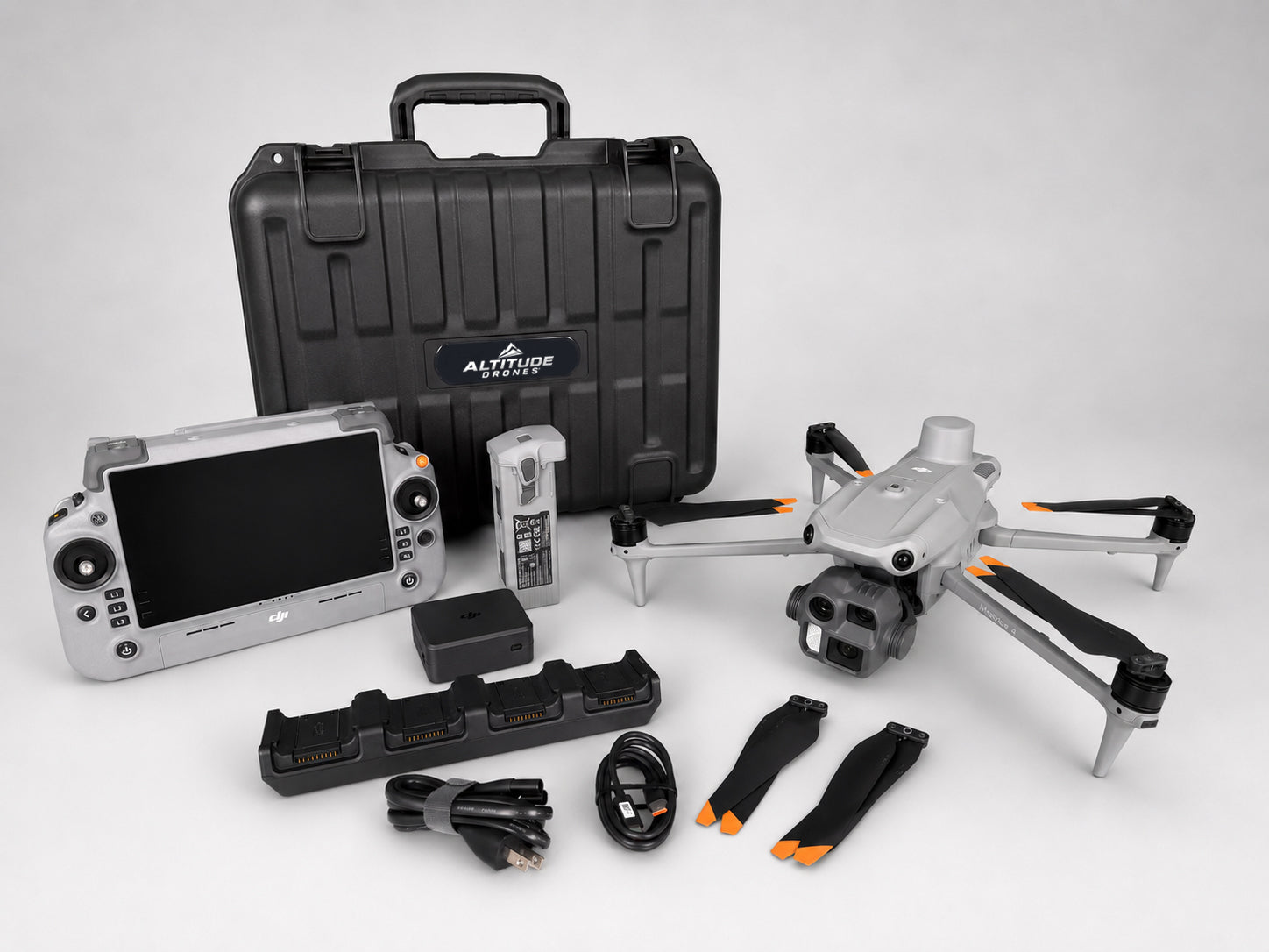
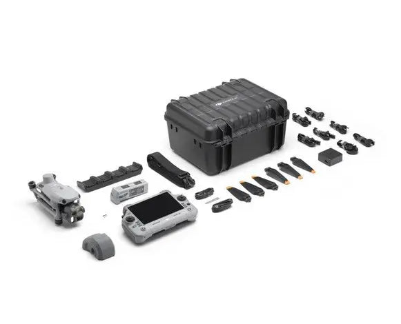
The Matrice 4E combo includes:
- 1x DJI Matrice 4E
- 1x DJI Matrice 4 Series Battery
- 1x DJI RC Plus 2 Enterprise
- 1x DJI 100W USB-C Power Adapter
- 1x DJI Matrice 4 Series Charging Hub
- 1x microSD Card
- 1x DJI Matrice 4E Gimbal Protector
- 1x DJI Cellular Dongle 2 Pry Bar
- 3x DJI Matrice 4 Series Propellers
- 1x 100W Power Adaptor AC Cable
- 1x USB-C to USB-C Data Cable
- 1x USB-A to USB-C Data Cable
- 1x DJI Matrice 4 Series Storage Case
- 1x DJI Matrice 4 Series Storage Case Shoulder Strap
You then have the option of selecting extras accessories from the options above!
Learn more about these options below:
Optional fast chargers:
The included OEM charging hub from DJI charges just one battery at a time. We offer several options for optional fast chargers to keep you in the air longer.
- AK M4T4 charging hub (most popular): this 300W hub can charge 4 batteries at once. It can charge the first two batteries in approximately 70-80 min and the remaining two in 30-40 additional minutes for an overall charge time of approximately 110 minutes for all 4. This option is a good blend of charging speed and cost.
- AK M4T8 charging case: this 600W charging case can charge up to 8 batteries in 110-120 minutes.
- Colorado Drone Chargers PRCS case: this option is the best in our opinion, allowing up to 4 batteries to be fully charged in approximately 60 min time. CDC is widely regarded as making the best fast chargers on the market. It charges the most batteries the fastest but costs more.
Optional WB37 controller battery: the controller for the Matrice 4 features a built-in battery with up to 7 hours of run time. You have the option of using an external DJI WB37 controller battery which fits in the back of the controller for an additional 4-6 hours of run time on extended operations. The battery is hot swappable and helps ensure you don't get grounded due to a dead controller. Optionally, you can also add the LKTOP charging hub to charge the WB37 battery independently of the controller. Alternatively, the WB37 can be charged while installed in the controller using the included OEM charger. Therefore, the charging hub for the WB37 is also an optional accessory but handy in situations where you are flying for hours at a time and need to ensure continued operations without interruption.
LKTOP WB37 charging hub: The optional WB37 remote battery can be charged while installed in the remote using the OEM charger, or this optional LKTOP charging hub allows for separate, faster charging of up to 2x batteries.
Mobile ops monitor case: Lastly, you can choose to add on a Seetec 21.5" rugged monitor case for enhanced mobile field ops. The Seetec case features a 1000nit daylight-bright monitor enclosed in a ruggedized case. This allows you to output the controller screen onto a larger viewing surface for better viewing of small details on the go. We recommended powering it with a vehicle power inverter or mobile power source such as a Jackery or EcoFlow lithium generator. This can also be used for mobile charging of drone batteries in the field.
DJI Manifold 3: the DJI Manifold 3 is an high performance onboard computing module that expands the capabilities of the DJI Matrice 4E by providing real-time data processing and intelligent automation directly on the drone. Equipped with up to 100 TOPS of AI computing power, 16GB of RAM, and 256GB of onboard storage, it allows advanced processing tasks to be performed directly on the aircraft instead of relying on a remote computer or cloud connection. For mapping applications, it enables advanced features such as smart 3D modeling and automated flight route generation, helping pilots capture more complete datasets with less manual planning. By reducing field time, improving data quality, and streamlining surveying and inspection workflows, the Manifold 3 is an excellent upgrade for mapping professionals looking to maximize the efficiency and value of their operations.
DJI LR-01 Obstacle Sensing Module: The DJI LR-01 Obstacle Sensing Module is an advanced LiDAR and millimeter-wave radar accessory for the DJI Matrice 4E that enhances obstacle detection beyond the drone’s built-in vision sensors. It can detect wires, branches, and other obstacles as small as 12mm thick at speeds up to 15 m/s, helping pilots safely operate in complex environments such as utility corridors, construction sites, and infrastructure inspections. For mapping missions, the LR-01 provides an extra layer of safety when flying near power lines, towers, and other hard-to-detect obstacles, reducing risk and increasing confidence during automated flight operations.
DJI D-RTK3 Multi-Function Station and Tripod/Survey Pole: The DJI D-RTK 3 Multifunctional Station is a high-precision GNSS base station that provides centimeter-level positioning accuracy for mapping drones such as the DJI Matrice 4E. When paired with the Survey Pole and Tripod Kit, it creates a stable, elevated reference point that broadcasts RTK corrections to the drone throughout the mission, significantly improving the accuracy of orthomosaics, point clouds, and 3D models. The D-RTK 3 can also be used as a rover for collecting ground control points and survey data, making it an ideal solution for surveyors, engineers, and mapping professionals who require highly accurate geospatial data while reducing the need for extensive ground control.
Emlid Reach RS3: The Emlid Reach RS3 is a professional GNSS receiver designed for survey-grade positioning with centimeter-level RTK/PPK accuracy. It features multi-band GNSS support, fast signal convergence, and built-in tilt compensation for faster and more efficient field measurements. Rugged, portable, and easy to use, the RS3 is widely used for land surveying, construction layout, GIS mapping, and drone data collection workflows.
DJI no longer provides a free Terra license with the 4E. One month free trial included.
Specifications
In The Box
DJI Matrice 4E: High-Precision Mapping and Surveying Platform
The DJI Matrice 4E is a next-generation enterprise drone designed specifically for high-accuracy mapping, surveying, construction monitoring, and industrial inspection workflows. Built for professionals who require precise geospatial data and efficient aerial workflows, the Matrice 4E delivers powerful imaging performance, intelligent automation, and reliable flight stability in demanding environments.
Compact and easy to deploy, the Matrice 4E is engineered to streamline data collection while maintaining the accuracy and consistency required for professional surveying and GIS applications.
Key Features and Benefits
Unparalleled Mapping Efficiency
- Extended Flight Time: Boasting a maximum flight time of 49 minutes, the Matrice 4E enables longer, more productive missions, minimizing downtime and maximizing operational output.
- 5-Directional Oblique Capture: This advanced feature improves mapping efficiency by up to 40%, enabling detailed 3D reconstructions and comprehensive aerial surveys.
- High-Speed Data Collection: With a 0.5-second capture interval, the Matrice 4E can collect data faster than ever, reducing operational time and increasing project throughput.
Precision Redefined
- Distortion Correction 2.0: Advanced distortion correction technology ensures residual distortion of less than two pixels, providing unmatched accuracy for aerial mapping and modeling.
- Factory-Calibrated Cameras: Each wide-angle camera is calibrated before leaving the factory, ensuring high-precision outputs. Combined with DJI Terra (available separately), the system delivers superior reconstruction accuracy.
Simplicity and Safety in Every Operation
- Smart 3D Capture: This innovative feature allows users to generate precise mapping routes and detailed 3D models directly from the RC Plus 2 remote controller, eliminating the need for additional devices.
- Enhanced Obstacle Avoidance: Navigate complex environments with confidence, thanks to robust obstacle avoidance systems that prioritize operational safety.
Applications
Surveying and Mapping
- Large-Scale Aerial Surveys: The Matrice 4E’s extended flight time, multi-directional capture, and high-speed data collection make it ideal for government departments, surveying firms, and planning organizations.
- Topographic Data Collection: Achieve unparalleled accuracy in digital terrain modeling and mapping with distortion correction and DJI Terra integration.
Construction and Planning
- Site Development and Modeling: Generate precise, detailed 3D models of construction sites and infrastructure projects, ensuring accurate planning and execution.
- Building Modeling: Perfect for architectural heritage conservation, detailed modeling projects, and fire safety planning.
Asset Inspections
- Infrastructure Inspections: Conduct thorough evaluations of bridges, buildings, and other structures using high-resolution imaging and flexible zoom options.
- High-Resolution Surface Analysis: Capture intricate details of surfaces for maintenance, repair, and operational assessments.
Why Buy the DJI Matrice 4E from Altitude Drones?
When you purchase your DJI Matrice 4E from Altitude Drones, you’re working with an authorized DJI dealer trusted by professionals nationwide since 2011.
We provide expert guidance, competitive pricing, fast shipping, financing options, and ongoing support to ensure your drone program operates at peak efficiency. From initial setup to long-term fleet expansion, Altitude Drones is here to support your mission every step of the way.
The Matrice 4E combo includes:
- 1x DJI Matrice 4E
- 1x DJI Matrice 4 Series Battery
- 1x DJI RC Plus 2 Enterprise
- 1x DJI 100W USB-C Power Adapter
- 1x DJI Matrice 4 Series Charging Hub
- 1x microSD Card
- 1x DJI Matrice 4E Gimbal Protector
- 1x DJI Cellular Dongle 2 Pry Bar
- 3x DJI Matrice 4 Series Propellers
- 1x 100W Power Adaptor AC Cable
- 1x USB-C to USB-C Data Cable
- 1x USB-A to USB-C Data Cable
- 1x DJI Matrice 4 Series Storage Case
- 1x DJI Matrice 4 Series Storage Case Shoulder Strap
You then have the option of selecting extras accessories from the options above!
Learn more about these options below:
Optional fast chargers:
The included OEM charging hub from DJI charges just one battery at a time. We offer several options for optional fast chargers to keep you in the air longer.
- AK M4T4 charging hub (most popular): this 300W hub can charge 4 batteries at once. It can charge the first two batteries in approximately 70-80 min and the remaining two in 30-40 additional minutes for an overall charge time of approximately 110 minutes for all 4. This option is a good blend of charging speed and cost.
- AK M4T8 charging case: this 600W charging case can charge up to 8 batteries in 110-120 minutes.
- Colorado Drone Chargers PRCS case: this option is the best in our opinion, allowing up to 4 batteries to be fully charged in approximately 60 min time. CDC is widely regarded as making the best fast chargers on the market. It charges the most batteries the fastest but costs more.
Optional WB37 controller battery: the controller for the Matrice 4 features a built-in battery with up to 7 hours of run time. You have the option of using an external DJI WB37 controller battery which fits in the back of the controller for an additional 4-6 hours of run time on extended operations. The battery is hot swappable and helps ensure you don't get grounded due to a dead controller. Optionally, you can also add the LKTOP charging hub to charge the WB37 battery independently of the controller. Alternatively, the WB37 can be charged while installed in the controller using the included OEM charger. Therefore, the charging hub for the WB37 is also an optional accessory but handy in situations where you are flying for hours at a time and need to ensure continued operations without interruption.
LKTOP WB37 charging hub: The optional WB37 remote battery can be charged while installed in the remote using the OEM charger, or this optional LKTOP charging hub allows for separate, faster charging of up to 2x batteries.
Mobile ops monitor case: Lastly, you can choose to add on a Seetec 21.5" rugged monitor case for enhanced mobile field ops. The Seetec case features a 1000nit daylight-bright monitor enclosed in a ruggedized case. This allows you to output the controller screen onto a larger viewing surface for better viewing of small details on the go. We recommended powering it with a vehicle power inverter or mobile power source such as a Jackery or EcoFlow lithium generator. This can also be used for mobile charging of drone batteries in the field.
DJI Manifold 3: the DJI Manifold 3 is an high performance onboard computing module that expands the capabilities of the DJI Matrice 4E by providing real-time data processing and intelligent automation directly on the drone. Equipped with up to 100 TOPS of AI computing power, 16GB of RAM, and 256GB of onboard storage, it allows advanced processing tasks to be performed directly on the aircraft instead of relying on a remote computer or cloud connection. For mapping applications, it enables advanced features such as smart 3D modeling and automated flight route generation, helping pilots capture more complete datasets with less manual planning. By reducing field time, improving data quality, and streamlining surveying and inspection workflows, the Manifold 3 is an excellent upgrade for mapping professionals looking to maximize the efficiency and value of their operations.
DJI LR-01 Obstacle Sensing Module: The DJI LR-01 Obstacle Sensing Module is an advanced LiDAR and millimeter-wave radar accessory for the DJI Matrice 4E that enhances obstacle detection beyond the drone’s built-in vision sensors. It can detect wires, branches, and other obstacles as small as 12mm thick at speeds up to 15 m/s, helping pilots safely operate in complex environments such as utility corridors, construction sites, and infrastructure inspections. For mapping missions, the LR-01 provides an extra layer of safety when flying near power lines, towers, and other hard-to-detect obstacles, reducing risk and increasing confidence during automated flight operations.
DJI D-RTK3 Multi-Function Station and Tripod/Survey Pole: The DJI D-RTK 3 Multifunctional Station is a high-precision GNSS base station that provides centimeter-level positioning accuracy for mapping drones such as the DJI Matrice 4E. When paired with the Survey Pole and Tripod Kit, it creates a stable, elevated reference point that broadcasts RTK corrections to the drone throughout the mission, significantly improving the accuracy of orthomosaics, point clouds, and 3D models. The D-RTK 3 can also be used as a rover for collecting ground control points and survey data, making it an ideal solution for surveyors, engineers, and mapping professionals who require highly accurate geospatial data while reducing the need for extensive ground control.
Emlid Reach RS3: The Emlid Reach RS3 is a professional GNSS receiver designed for survey-grade positioning with centimeter-level RTK/PPK accuracy. It features multi-band GNSS support, fast signal convergence, and built-in tilt compensation for faster and more efficient field measurements. Rugged, portable, and easy to use, the RS3 is widely used for land surveying, construction layout, GIS mapping, and drone data collection workflows.
DJI no longer provides a free Terra license with the 4E. One month free trial included.
Contact Us
Questions? Need a quote?
FAQ
Check out the most common questions our customers ask. Still have questions? Contact our customer support.
Are all DJI drones the same?
No, they are not. Be careful of other sellers advertising DJI drones at bargain prices or selling only through social media or online marketplaces. Often times, these are "black market" drones intended for use in another country like Nigeria or South Africa. They are cheap because they were pre-activated overseas before being shipped. We sell un-activated models and can assist our customers with repairs.
Are you an authorized DJI and Autel dealer?
Yes, we are an authorized dealer for all the brands we sell to include DJI, Autel, JZ, CZI, and many more.
Do you offer financing on drones?
Do you accept government/corporate purchases?
Yes! We sell to government and corporate/enterprise clients all the time and can accept purchase orders. Contact us today for a quote or to learn more.
Do you offer DJI drone repairs?
We do! We have partnered with Drone-Works to offer repairs on select DJI drones. Visit here for more info: DJI Repairs
How long will it take to get my order?
It depends on where you are located and the shipping method. We try to ship all orders within 1 business day. Transit time to most locations in the U.S. from us in Colorado is typically just 2-5 business days.
Do you offer local pickup?
Yes! We allow our local customers to pick up products from our Johnstown, Colorado, location. Select pickup during checkout and contact us to schedule a time.