Freefly Astro Max Mapping Bundle (NDAA/BlueUAS)
Contact us to buy this item
:%20Mission-Ready%20Aerial%20Mapping%20System%0AThe%20Freefly%20Astro%20Max%20Mapping%20Bundle%20(NDAA/Blue)%20delivers%20unmatched%20precision,%20compliance,%20and%20reliability%20for%20gove...
)
Description
Freefly Astro Max Mapping Bundle (NDAA/Blue): Mission-Ready Aerial Mapping System
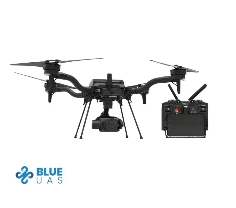
The Freefly Astro Max Mapping Bundle (NDAA/Blue) delivers unmatched precision, compliance, and reliability for government and enterprise mapping operations. Every component—aircraft, payload, controller, and radio link—is NDAA and DIU Blue approved, meeting the highest standards for secure U.S. operations. Designed for demanding field missions, this bundle combines the Astro Max aircraft with the Sony ILX-LR1 61 MP camera, Sigma 24 mm f/3.5 mapping lens, Doodle Labs 2.4 GHz Blue-certified radio, and a complete SL8 power suite for sustained, survey-grade performance.
Secure and Compliant by Design
The Astro Max NDAA/Blue is built for organizations requiring dependable U.S.-made components and certified systems. Its aircraft, Pilot Pro Controller, and radio link are all NDAA and DIU Blue compliant. The system ships with Standard Remote ID preconfigured for FAA compliance and can be disabled upon submission of proper exemption documentation. With open interface specifications and RTK readiness, it ensures accurate, consistent data capture while meeting strict procurement and operational security requirements.
Reliable Field Performance and Workflow Efficiency
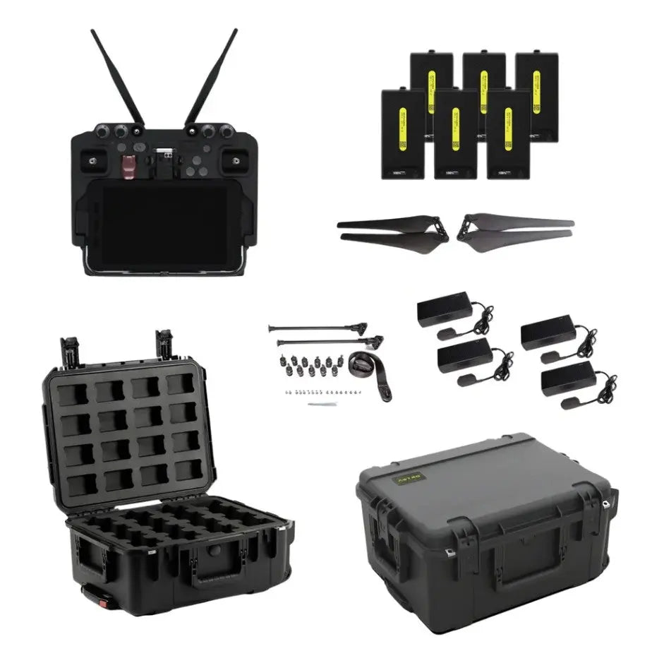
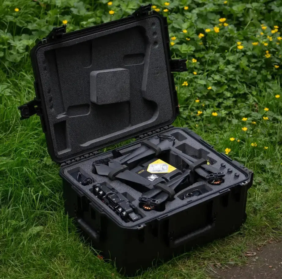
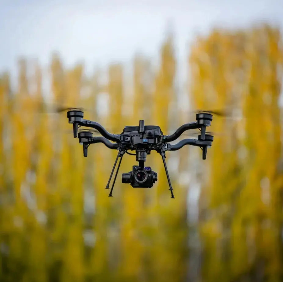
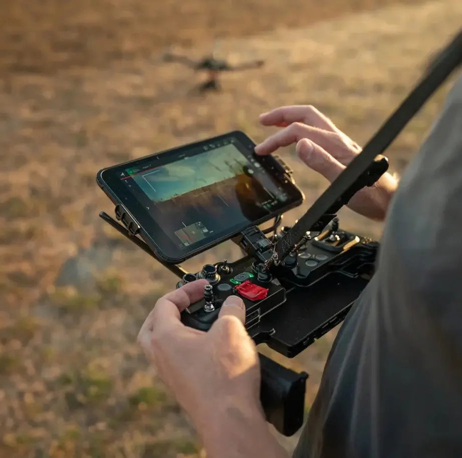
This bundle is configured for continuous mission cycles, with six SL8-Air batteries, four SL8 Fast Chargers, and a durable travel case for organized transport. The Pilot Pro Controller includes a preinstalled Samsung Active Tab 3 and a Doodle Labs 2.4 GHz Blue radio, offering secure and robust control links. The vibration-isolated Freefly Gimbal ensures sharp imaging, while the Sony ILX-LR1 delivers 61 MP geotagged photos ready for professional mapping software. Standard Remote ID and BVLOS compliance expand operational flexibility for qualified teams.
Key Features and Benefits
- Fully NDAA and DIU Blue approved aircraft, controller, and radio link
- Sony ILX-LR1 61 MP full-frame camera with Sigma 24 mm f/3.5 lens
- Freefly Astro Max: compact industrial platform with open interface specs
- Quick-detach, vibration-isolated Freefly Gimbal for sharp imagery
- Pilot Pro Controller with preinstalled Samsung Active Tab 3 tablet
- Doodle Labs 2.4 GHz Blue radio ensures secure, compliant communications
- Six SL8-Air batteries and four SL8 Fast Chargers for sustained missions
- RTK ready via user-supplied ground-station computer
- Standard Remote ID preinstalled for FAA compliance (override available)
- 2270 high-efficiency propellers extend flight time by roughly 10 percent
- Spare Parts Kit and SL8 Travel Case included for field logistics
- Manual Mode proficiency recommended for emergency procedures
Compatibility and Integration
- Works with Freefly Pilot Pro Controller and Doodle Labs Blue radio link
- Supports RTK GPS Ground Station through user-supplied computer
- Outputs standard geotagged imagery compatible with major mapping software
- LTE modem functionality available in the U.S. only
- Uses Freefly SL8-Air batteries and SL8 Fast Chargers
Applications and Use Cases
- Government and enterprise mapping: secure, NDAA/Blue-compliant operations
- Survey and topographic mapping: centimeter-level terrain accuracy
- Construction monitoring: document progress and volumetric data
- Infrastructure and utility inspection: compliant data collection workflows
- Urban planning and GIS modeling: generate orthomosaics and 3D maps
- Mining and resource surveying: precise 3D volume analysis
- Environmental assessment: track vegetation or erosion trends
- Disaster response: perform fast, secure aerial documentation
- Research and defense projects: collect data with U.S.-compliant hardware
Built for Mission-Critical Mapping and Compliance
The Astro Max Mapping Bundle (NDAA/Blue) is engineered for professionals who operate under the most stringent data-security and regulatory standards. Its fully compliant design, integrated power system, and precision imaging tools enable repeatable, high-accuracy results with minimal downtime. From planning to post-processing, it ensures operational confidence and consistent output in every mission.
Specifications
In The Box
Freefly Astro Max Mapping Bundle (NDAA/Blue): Mission-Ready Aerial Mapping System
The Freefly Astro Max Mapping Bundle (NDAA/Blue) delivers unmatched precision, compliance, and reliability for government and enterprise mapping operations. Every component—aircraft, payload, controller, and radio link—is NDAA and DIU Blue approved, meeting the highest standards for secure U.S. operations. Designed for demanding field missions, this bundle combines the Astro Max aircraft with the Sony ILX-LR1 61 MP camera, Sigma 24 mm f/3.5 mapping lens, Doodle Labs 2.4 GHz Blue-certified radio, and a complete SL8 power suite for sustained, survey-grade performance.
Secure and Compliant by Design
The Astro Max NDAA/Blue is built for organizations requiring dependable U.S.-made components and certified systems. Its aircraft, Pilot Pro Controller, and radio link are all NDAA and DIU Blue compliant. The system ships with Standard Remote ID preconfigured for FAA compliance and can be disabled upon submission of proper exemption documentation. With open interface specifications and RTK readiness, it ensures accurate, consistent data capture while meeting strict procurement and operational security requirements.
Reliable Field Performance and Workflow Efficiency
This bundle is configured for continuous mission cycles, with six SL8-Air batteries, four SL8 Fast Chargers, and a durable travel case for organized transport. The Pilot Pro Controller includes a preinstalled Samsung Active Tab 3 and a Doodle Labs 2.4 GHz Blue radio, offering secure and robust control links. The vibration-isolated Freefly Gimbal ensures sharp imaging, while the Sony ILX-LR1 delivers 61 MP geotagged photos ready for professional mapping software. Standard Remote ID and BVLOS compliance expand operational flexibility for qualified teams.
Key Features and Benefits
- Fully NDAA and DIU Blue approved aircraft, controller, and radio link
- Sony ILX-LR1 61 MP full-frame camera with Sigma 24 mm f/3.5 lens
- Freefly Astro Max: compact industrial platform with open interface specs
- Quick-detach, vibration-isolated Freefly Gimbal for sharp imagery
- Pilot Pro Controller with preinstalled Samsung Active Tab 3 tablet
- Doodle Labs 2.4 GHz Blue radio ensures secure, compliant communications
- Six SL8-Air batteries and four SL8 Fast Chargers for sustained missions
- RTK ready via user-supplied ground-station computer
- Standard Remote ID preinstalled for FAA compliance (override available)
- 2270 high-efficiency propellers extend flight time by roughly 10 percent
- Spare Parts Kit and SL8 Travel Case included for field logistics
- Manual Mode proficiency recommended for emergency procedures
Compatibility and Integration
- Works with Freefly Pilot Pro Controller and Doodle Labs Blue radio link
- Supports RTK GPS Ground Station through user-supplied computer
- Outputs standard geotagged imagery compatible with major mapping software
- LTE modem functionality available in the U.S. only
- Uses Freefly SL8-Air batteries and SL8 Fast Chargers
Applications and Use Cases
- Government and enterprise mapping: secure, NDAA/Blue-compliant operations
- Survey and topographic mapping: centimeter-level terrain accuracy
- Construction monitoring: document progress and volumetric data
- Infrastructure and utility inspection: compliant data collection workflows
- Urban planning and GIS modeling: generate orthomosaics and 3D maps
- Mining and resource surveying: precise 3D volume analysis
- Environmental assessment: track vegetation or erosion trends
- Disaster response: perform fast, secure aerial documentation
- Research and defense projects: collect data with U.S.-compliant hardware
Built for Mission-Critical Mapping and Compliance
The Astro Max Mapping Bundle (NDAA/Blue) is engineered for professionals who operate under the most stringent data-security and regulatory standards. Its fully compliant design, integrated power system, and precision imaging tools enable repeatable, high-accuracy results with minimal downtime. From planning to post-processing, it ensures operational confidence and consistent output in every mission.
Contact Us
Questions? Need a quote?
FAQ
Check out the most common questions our customers ask. Still have questions? Contact our customer support.
Do you offer financing on drones?
Do you accept government/corporate purchases?
Yes! We sell to government and corporate/enterprise clients all the time and can accept purchase orders. Contact us today for a quote or to learn more.